Napa Valley Vine Trail
The Vine Trail is a 47-mile walking and biking trail that connects the entire Napa Valley – from Vallejo to Calistoga. For more on the Vine Trail, click here.
NVTA is currently constructing the 9-mile-long St. Helena – Calistoga segment. We kindly ask people to stay off Construction broke ground on May 24, 2022.

Updates!
July 25: Ghilotti, the contractor, has completed grading in Calistoga. They are now working on Dunaweal Lane Bridge and State Route 29 between Dunaweal Lane and Larkmead Lane. NVTA is coordinating its work with the PG&E gasline replacement, Caltrans repaving, and other local projects in order to minimize disruption.
July 5: There were shovels in the ground starting in Calistoga on Fairway Drive behind the Calistoga Depot.
June 30: Construction on the Vine Trail started with surveying and staking.


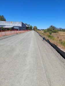
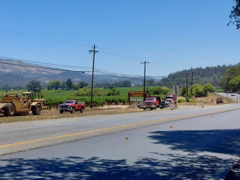
Recent Photos of Vine Trail Construction from St. Helena to Calistoga. (Photo credit: Thomas “TC” Hurley)
THE NAPA VALLEY VINE TRAIL
The Napa Valley Vine Trail is a walking and biking trail connecting the entire Napa Valley. When completed this 47-mile trail will be the key link in Napa County’s county-wide trail system which also includes portions of the region-wide Bay Trail and Ridge Trail. Detailed planning for the Napa Valley Vine Trail was started by the Napa County Transportation and Planning Agency when, in 2007, they commissioned The Greenway Feasibility Study. This Study was completed in 2008 and formally accepted by NCTPA (Now NVTA) in March 2009.
Its conclusion was that a Class I trail (separated from the roadway) on the Valley floor was feasible and should be pursued. The non-profit Napa Valley Vine Trail Coalition, a unique partnership, made up of 27 of the county’s most influential non-profit and government groups was formed to implement the Class I Multi-use Path the full length of Napa Valley.

THE ST. HELENA TO CALISTOGA SEGMENT
The Napa Valley Vine Trail – St. Helena to Calistoga project would consist of an approximately 6.8-mile Class I bicycle and pedestrian trail within St. Helena and Napa County. The Napa Valley Vine Trail – St. Helena to Calistoga project would be located within California Department of Transportation (Caltrans) right of way (ROW), State Park lands, existing easements, and easements to be granted from property owners. The St. Helena to Calistoga project would begin in St. Helena at the intersection of Pratt Avenue and State Route (SR) 29 at postmile (PM) 29.244 and extends to the north end where it would terminate at Dunaweal Lane east of SR 29 at PM 35.308 near the city limits of Calistoga.
The proposed path would be 10-feet wide with 2-foot shoulders for a total width of 14 feet in most locations, narrowing to a lesser width (minimum 8 feet) in constrained locations. In most locations the Vine Trail would be an asphalt trail installed over aggregate base, with gravel shoulders. With exception of a portion of Vine Trail through Bothe-Napa Valley State Park, most of the proposed Vine Trail would be on the east side of SR 29. Most of the Vine Trail would be separated from SR 29, though a few portions of the proposed Vine Trail would occur on the shoulder of SR 29.
An additional segment called the Fair Way Path Extension would be constructed at the same time as the proposed project. The Fair Way Extension would be a 0.6-mile Class I trail that extends north from an existing segment of the Napa Valley Vine Trail, from Washington Avenue in Calistoga to the intersection of Fair Way and Lincoln Avenue in Calistoga (east of SR 29 and approximately between PM 36.45 to 37.22). The Fair Way Path Extension was previously analyzed under CEQA and a Mitigated Negative Declaration has been approved by the City of Calistoga’s Planning Commission (PC Resolution 2014-29; November 26, 2014).
Mitigated Negative Declaration
The NVTA Board of Directors held a Special Meeting on Wednesday August 19, 2020. The Board approved the California Environmental Quality Act (CEQA) Mitigated Negative Declaration for the Napa Valley Vine Trail St Helena to Calistoga Section. The final documents are available at the links below:
- CEQA Initial Study/Mitigated Negative Declaration Napa Valley Vine Trail: St Helena to Calistoga Section
- Mitigation Monitoring and Reporting Program
Project Construction
NVTA released an Invitation to Bid for the St. Helena to Calistoga Segment on December 23, 2021. A total of seven bids were received on February 2, 2022. NVTA is in the process of reviewing the bids received and is working to award the construction contract and start construction in the Spring of 2022.
THE OAK KNOLL SEGMENT
CLICK HERE TO READ THE OAK KNOLL SEGMENT FACT SHEET
NVTA secured nearly $7 million in state and federal funds for the 6-mile stretch of Vine Trail linking Napa to Yountville along Solano Avenue, a project totaling about $10 million. NVTA is project sponsor for the Oak Knoll segment, a unique collaboration between the private Napa Valley Vine Trail Coalition, local agencies and Caltrans. With the Oak Knoll Segment finished, 12.5 miles of Class I paths are now available for bicyclists & pedestrians to travel safely between Napa and Yountville. When complete, the Vine Trail will be a 47-mile path linking the Napa Valley from Calistoga to the Vallejo Ferry Terminal.
CLICK HERE TO GO TO THE VINE TRAIL COALITION WEBSITE